Posts Tagged: Climate
Paper highlights how climate change challenges, transforms agriculture
As the climate continues to change, the risks to farming are only going to increase.
That's the key takeaway from a recent paper published by a team that included UC Merced and UC Agriculture and Natural Resources researchers. The paper dives into what those challenges are, how farmers are working to address them and what should come next.
"Climate Smart Agriculture: Assessing Needs and Perceptions of California's Farmers" was first authored by Samuel Ikendi, academic coordinator, with Tapan Pathak, UC Cooperative Extension climate adaptation in agriculture specialist, as a corresponding author. Both are based at UC Merced. Pathak is also a project director of National Institute of Food and Agriculture-funded project "Multifaceted Pathways to Climate-Smart Agriculture through Participator Program Development and Delivery," which supported this study. The study appeared in the open access journal Frontiers in Sustainable Food Systems.
The needs assessment was designed to understand farmers' perceptions and experiences with climate change exposures; the risk management practices they currently use; and what tools and resources would assist them in making strategic decisions.
Of the farmers surveyed, roughly two-thirds agree climate change is occurring and requires action. Even more said they are interested in learning more about the impacts of climate change on the agricultural industry. Most respondents said they experience greater climate change impacts on their farms today compared with 10 years ago.
Farmers were very concerned with water-related issues, with those in the San Joaquin Valley, Central Coast and Inland Empire areas particularly worried about a reduction in the availability of groundwater. Increased drought severity was a very significant concern among farmers in the Inland Empire, Central Coast and Southern regions. Farmers in the North Coast and Southern regions were concerned about increased damage to crops due to wildfire.
Closely related were temperature-related issues, including crop damage due to extreme heat.
Those who farm vegetables were more concerned about water availability for irrigation, while fruit farmers were more concerned about increased crop/water stress and increased crop damage due to extreme heat.
Many respondents said they are implementing climate adaptation practices including managing water resources, maintaining soil health and making more use of renewable energy sources. They are seeking insurance and government help to pay for these adaptations and increase their agricultural resilience, the researchers wrote.
The farmers expressed interest in learning more about measures they might take to mitigate climate change. But they cited significant barriers to this work, including government regulations, high implementation cost, labor access/cost, access to water and the availability of money to pay for it.
"Climate change is significantly altering California's highly diverse agricultural landscape, posing challenges such as increased water stress, heat stress, and shifting growing seasons," Pathak said. "Climate-smart agriculture practices can alleviate some of those stresses."
But, he said, research and UC Cooperative Extension efforts only have value if they lead to enhanced climate-informed decision-making at the local level.
"Assessing their level of knowledge, perception and needs will help in tailoring research and extension activities that are most relevant to farmers on the ground," Pathak said. "Results from this study could also provide important policy insights on financial incentives and technical assistance."
Climate-smart crop production workshops March 5-7 in Ventura, Salinas and Tulare
Growers invited to learn how to manage risks to fruit, nut, vegetable production
UC Cooperative Extension is offering workshops in Ventura, Salinas and Tulare to help growers adapt their fruit, nut and vegetable production practices to variable climate conditions.
"Growers, farm and ranch managers, and technical assistance providers can learn about the latest research and advances in managing risks to agricultural production that can result from climate change and climate variability,” said Daniele Zaccaria, associate professor in agricultural water management for Cooperative Extension at UC Davis.
Tapan Pathak, UCCE specialist at UC Merced, will speak about climate change trends, potential impacts on agricultural production and decision support tools. Zaccaria and local experts will discuss cover cropping, pests and other issues.
During a roundtable session, participants will discuss their own production challenges resulting from climate change and variability.
“Participants will also learn about tools available to aid manage climate change and climate variability risks," Zaccaria said.
The Climate-Smart Agricultural Production Practices workshops will be held in three locations:
Ventura: Vegetable and Berry Production
March 5 (8 a.m.–1:30 p.m.)
669 County Square Dr., Suite 100
Speakers include UCCE advisors Andre Biscaro, Ben Faber and Mark Battany, and other scientists and experts from Ventura County Resource Conservation District and Land IQ. Register at https://bit.ly/VenturaCrops.
Salinas: Vegetable, Berry and Grapevine Production
March 6 (8 a.m. –2 p.m.)
1432 Abbott St.
Speakers include Daniel Hasegawa and Eric Brennan of USDA-ARS and UCCE advisors Larry Bettiga, Michael Cahn and Mark Bolda. Register at https://bit.ly/SalinasCrops.
Tulare: Fruit and Nut Production
March 7 (8 a.m.–2 p.m.)
4500 South Laspina St.
Speakers include UCCE advisors Jhalendra Rijal, Mark Battany, Mohammad Yaghmour, Sandipa Gautam, Brent Holtz and other scientists and experts from USDA-NRCS, Almond Board of California; California Pistachio Research Board and Land IQ. Register at https://bit.ly/TulareCrops.
Workshops are free and include coffee breaks, lunch, workshop materials along with the presentations. Registration is required.
These workshops are supported by grants from the California Department of Food and Agriculture and USDA's National Institute of Food and Agriculture.
No-till annual wheat better for soil health in California’s climate
One more reason to adopt sustainable cultivation
California wheat farmers could both maintain their yields and improve soil health by growing annual wheat without tilling the soil year after year.
This could be one more encouragement to farmers to adopt a sustainable practice commonly called conservation tillage, no-till or minimum-till cultivation, impacting how we grow a grain that supplies about 20 percent of the calories and protein for people around the world.
A new study, by a team led by Mark Lundy, University of California Cooperative Extension specialist in UC Davis' Department of Plant Sciences, offers new insight for decades-long discussions around soil conservation, sustainable agriculture and climate-warming emissions related to growing our food. The study has been published in the journal Soil and Tillage Research. For the first time, researchers have shown that annual wheat that is not tilled each year is better for stashing carbon in the soil than perennial wheatgrass, while still yielding more crop in Central California.
Previous studies have looked at annual wheat that is tilled each year, annual wheat that is not tilled, and a cousin species, perennial intermediate wheatgrass (trademarked Kernza), which also is not tilled. But until now, no one has looked at all of the benefits and trade-offs together. Most importantly, “no one has ever controlled for tillage,” Lundy said. “And, no one has compared annual wheat to perennial intermediate wheatgrass over multiple years in a Mediterranean climate, which is what we have in California.”
This study also is unique because it delves into the deeper question of what is going on in the soil that drives the different results for carbon there. Soil carbon reflects various processes linked to plant activity and soil health. Measuring the different forms of soil carbon may also signal whether a farming system is accumulating carbon in the soil over time – a plus for reducing climate-warming gases in the atmosphere.
“Measuring soil carbon is complex and nuanced,” said Kalyn Taylor, the lead author on the paper. “We started this experiment because we wanted to know whether and how plant activity and tilling or not tilling would affect the carbon story belowground in California's climate.”
“When we started this study, we thought the crop being perennial or annual would drive the differences in carbon storage in the soil,” Lundy added. Specifically, they had expected perennial wheatgrass would lead to more carbon in the soil because of its deeper, better-established root system. “But that's not what we found,” he went on. “What we found was, it was the lack of tillage, plus the level of productivity of common annual wheat, that made the difference in soil carbon here in California.”
Soil carbon in annual vs. perennial grain
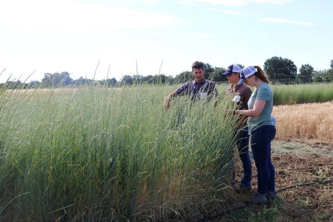
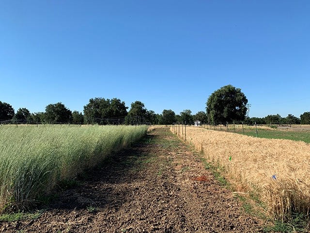
In 2017, Lundy, then-graduate-student Taylor, UC Davis Professor Emeritus Kate Scow and others on the team started measuring different forms of soil carbon in test plots at Russell Ranch, west of campus. Plots were planted with annual wheat that was tilled each spring, annual wheat that was not tilled and perennial intermediate wheatgrass (Kernza) that also was not tilled.
Each year, the researchers measured the carbon present in the soil, the amount of soil organisms (which have carbon in their bodies) and the amount of material the plants created.
At the end of three growing seasons, they found that land planted with no-till, common, annual wheat had the highest amount of soil organisms, measured as biomass, of the three treatments.
The researchers also found soil carbon is more likely to remain stable in the no-till, annual plots, compared to both tilled wheat and wheatgrass.
In addition, the no-till, annual wheat produced plant material more consistently than the perennial wheatgrass across the three years, which saw variation in rainfall.
“Overall, annual wheat grown without soil disturbance or tillage had both higher productivity and higher potential for storing carbon in the topsoil than perennial wheatgrass in our Mediterranean climate,” Lundy said.
Related research
“No-till annual wheat increases plant productivity, soil microbial biomass, and soil carbon stabilization relative to intermediate wheatgrass in a Mediterranean climate,” is online now and will be published in the January 2024 edition of Soil and Tillage Research.
The team also found that tilled annual wheat vs. Kernza stores total carbon at different depths in the soil profile and hosts distinct soil fungal communities, primarily in the root zone and topsoil: Taylor, K., Samaddar, S., Schmidt, R., Lundy, M. and Scow, K., 2023. Soil carbon storage and compositional responses of soil microbial communities under perennial grain IWG vs. annual wheat. Soil Biology and Biochemistry, p.109111.
Previous work comparing the perennial grain known as intermediate wheatgrass (trademarked Kernza) to annual wheat had not distinguished the extent to which soil health benefits are a function of the perennial nature of the crop. Read the story here.
This story was originally published on the UC Davis News site.
Researchers create app to help drones improve farm efficiency
When flown at the right times, drones can help farmers adapt to a changing climate
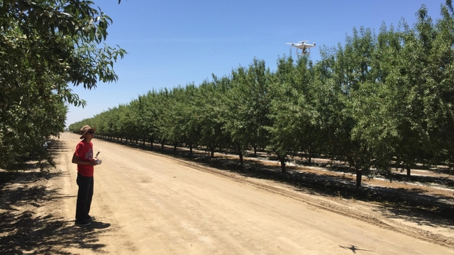
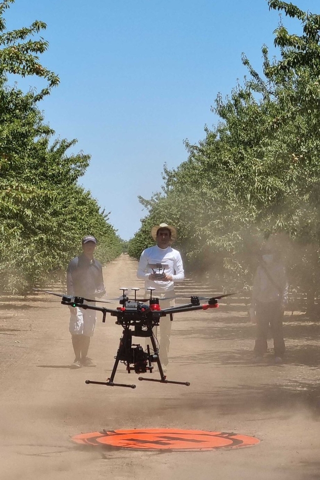
Researchers at the University of California, Davis, have developed a web application to help farmers and industry workers use drones and other uncrewed aerial vehicles, or UAVs, to generate the best possible data. By helping farmers use resources more efficiently, this advancement could help them adapt to a world with a changing climate that needs to feed billions.
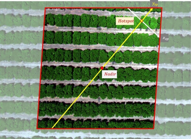
Associate Professor Alireza Pourreza, director of the UC Davis Digital Agriculture Lab and postdoctoral researcher Hamid Jafarbiglu, who recently completed his doctorate in biological systems engineering under Pourreza, designed the When2Fly app to make drones more proficient and accurate. Specifically, the platform helps drone users avoid glare-like areas called hotspots that can ruin collected data.
Drone users select the date they plan to fly, the type of camera they are using and their location either by selecting a point on a map or by entering coordinates. The app then indicates the best times of that specific day to collect crop data from a drone.
Jafarbiglu and Pourreza, who is also a UC Cooperative Extension specialist of agricultural mechanization, said that using this app for drone imaging and data collection is crucial to improve farming efficiency and mitigate agriculture's carbon footprint. Receiving the best data — like what section of an orchard might need more nitrogen or less water, or what trees are being affected by disease — allows producers to allocate resources more efficiently and effectively.
"In conventional crop management, we manage the entire field uniformly assuming every single plant will produce a uniform amount of yield, and they require a uniform amount of input, which is not an accurate assumption," said Pourreza. "We need to have an insight into our crops' spatial variability to be able to identify and address issues timely and precisely, and drones are these amazing tools that are accessible to growers, but they need to know how to use them properly."
Dispelling the solar noon belief
In 2019, Jafarbiglu was working to extract data from aerial images of walnut and almond orchards and other specialty crops when he realized something was wrong with the data.
"No matter how accurately we calibrated all the data, we were still not getting good results," said Jafarbiglu. "I took this to Alireza, and I said, 'I feel there's something extra in the data that we are not aware of and that we're not compensating for.' I decided to check it all."
Jafarbiglu pored through the 100 terabytes of images collected over three years. He noticed that after the images had been calibrated, there were glaring bright white spots where they were supposed to look flat and uniform.
But it couldn't be a glare because the sun was behind the drone taking the image. So Jafarbiglu reviewed literature going back to the 1980s in search of other examples of this phenomenon. Not only did he find mentions of it, but also that researchers had coined a term for it: hotspot.
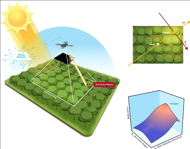
A hotspot happens when the sun and UAV are lined up in such a way that the drone is between the viewable area of the camera's lens system and the sun. The drone takes photos of the Earth, and the resulting images have a gradual increase in brightness toward a certain area. That bright point is the hotspot.
The hotspots are a problem, Jafarbiglu said, because when collecting UAV data in agriculture, where a high level of overlap is required, observed differences in the calibrated images need to come solely from plant differences.
For example, every plant may appear in 20 or more images, each from varying view angles. In some images, the plant might be close to the hotspot, while in others it may be situated further away, so the reflectance may vary based on the plant's distance from the hotspot and spatial location in the frame, not based on any of the plant's inherent properties. If all these images are combined into a mosaic and data are extracted, the reliability of the data would be compromised, rendering it useless.
Pourreza and Jafarbiglu found that the hotspots consistently occurred when drones were taking images at solar noon in mid-summer, which many believe is the best time to fly drones. It's an obvious assumption: the sun is at its highest point above the Earth, variations in illumination are minimal, if not steady and fewer shadows are visible in the images. However, sometimes that works against the drone because the sun's geometrical relationship to the Earth varies based on location and the time of year, increasing the chance of having a hotspot inside the image frame when the sun is higher in the sky.
"In high-latitude regions such as Canada, you don't have any problem; you can fly anytime. But then in low-latitude regions such as California, you will have a little bit of a problem because of the sun angle," Pourreza said. "Then as you get closer to the equator, the problem gets bigger and bigger. For example, the best time of flight in Northern California and Southern California will be different. Then you go to summer in Guatemala, and basically, from 10:30 a.m. to almost 2 p.m. you shouldn't fly, depending on the field-oriented control of the camera. It's exactly the opposite of the conventional belief, that everywhere we should fly at solar noon."
Grow technology, nourish the planet
Drones are not the only tools that can make use of this discovery, which was funded by the AI Institute for Next Generation Food Systems. Troy Magney, an assistant professor of plant sciences at UC Davis, mainly uses towers to scan fields and collect plant reflectance data from various viewing angles. He contacted Jafarbiglu after reading his research, published in February in the ISPRS Journal of Photogrammetry and Remote Sensing, because he was seeing a similar issue in the remote sensing of plants and noted that it's often ignored by end users.
"The work that Hamid and Ali have done will be beneficial to a wide range of researchers, both at the tower and the drone scale, and help them to interpret what they are actually seeing, whether it's a change in vegetation or a change in just the angular impact of the signal," he said.
For Pourreza, the When2Fly app represents a major step forward in deploying technology to solve challenges in agriculture, including the ultimate conundrum: feeding a growing population with limited resources.
"California is much more advanced than other states and other countries with technology, but still our agriculture in the Central Valley uses technologies from 30 to 40 years ago," said Pourreza. "My research is focused on sensing, but there are other areas like 5G connectivity and cloud computing to automate the data collection and analytics process and make it real-time. All this data can help growers make informed decisions that can lead to an efficient food production system. When2Fly is an important element of that."
This article was originally published on the UC Davis College of Engineering News page.
Indigenous science key to adapting to climate change
UC Berkeley and Karuk Tribe use Indigenous and western science to cultivate resilient food systems under changing climate conditions.
To adapt to climate change, Karuk Tribe members identified the importance of monitoring climate stress on plant species and actively managing and restoring healthy ecosystem processes to increase the consistency and quality of their food harvests, according to a new report. The Karuk Tribe's Aboriginal Territory encompasses over a million acres in the Klamath Basin in Northern California and Southern Oregon.
The Karuk Tribe-UC Berkeley Collaborative has released findings from its four-year collaborative research in their report “Karuk Agroecosystem Resilience and Cultural Foods and Fibers Revitalization Initiative: xúus nu'éethti – we are caring for it.”
To assess climate-change impacts on cultural-use plants and their habitats and to develop strategies and tools for long-term monitoring, this project integrated Indigenous and western science perspectives.
“Understanding the breadth and intensity of climate change with regard to our cultural resources is key to developing adequate response plans,” said Karuk cultural practitioner and project co-lead Lisa Morehead-Hillman. “Without healthy stands (of trees), our cultural practices suffer. We all suffer.”
The report authors lay out specific place-based management and monitoring actions that will enhance the resilience of cultural focal species and habitats to climate change, climate variability and management threats.
To support the resilience of Indigenous cultural agroecosystems and cultural food and fiber species, as well as strengthening Indigenous food sovereignty now and into the future, the authors recommend the following management, policy, research and institutional actions:
• Supporting Karuk Tribal natural resource, data and knowledge sovereignty through appropriate engagement and Tribal oversight.
• Investing in Tribal management infrastructure and workforce development to support culturally appropriate, place-based job opportunities for Tribal members and descendants.
• Supporting co-management and family-based stewardship of cultural use plants and habitats on Karuk Aboriginal lands.
• Investing in and supporting the re-acquisition of Karuk Aboriginal lands to build back the Tribal land base and restore habitats and ecosystems.
• Funding research, monitoring, and educational opportunities that can support youth leadership development, job creation, agroecosystem resilience, and food sovereignty in Karuk Aboriginal Territory.
This research builds on the findings from a five-year Karuk Tribe-UC Berkeley Collaborative food security project (2012-2018), which found that 92% of all Tribal households in the Klamath River Basin experienced some level of food insecurity, and that having access to cultural foods was a strong predictor of food security, yet only 7% of all Tribal households had access to good quality cultural foods at all times.
“This project applies what we learned from tribal members about food insecurity and climate and land management threats to cultural foods to the landscape level, co-creating methods and tools with our Karuk colleagues to assess and restore the health, quality and abundance of cultural foods and fibers to promote food security and eco-cultural resilience,” said Jennifer Sowerwine, lead UC Berkeley collaborator and associate professor of Cooperative Extension.
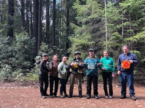
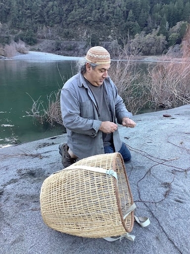
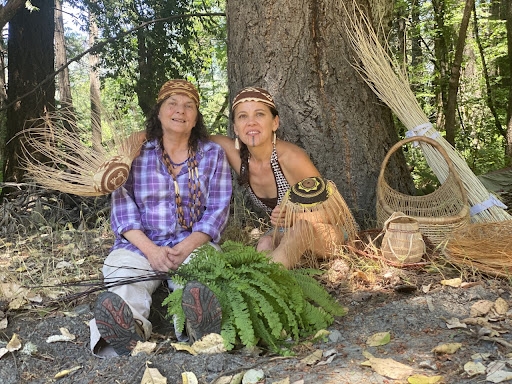
Research objectives centered around the “Agroecosystem Condition Assessment,” in which UC Berkeley and Karuk researchers and cultural practitioners assessed the health, quality and yield of 20 cultural-use focal plants prioritized by the Karuk Tribe, such as tanoak acorns, evergreen huckleberry, bear grass and hazel, as well as the condition of their habitats.
“This project demonstrates the benefits of working with a diverse research partnership in the co-production of climate science using blended Indigenous and Western research and monitoring methods,” said project collaborator Frank Lake, research ecologist and USDA Forest Service Pacific Southwest tribal liaison. “This project exemplifies recent federal directives and initiatives to support tribes for climate adaptation, forest restoration and eco-cultural revitalization.”
The overall quality and condition of most of the focal species found in the research plots and patches reflect both the devastating impact of colonial land-management practices – including timber harvest, fire exclusion and mining – as well as clear evidence of climate stress such as aborted fruit, early die back and poor-quality product. Forced exclusion of cultural management is reflected in encroachment of invasive species, inappropriate canopy cover and poor-quality harvests impacting both human and animal access to these important plant resources.
“This work done among Indigenous knowledge holders and academia is paramount to developing and sustaining a well-trained workforce for the future,” said Bill Tripp, director of the Karuk Tribe Department of Natural Resources and project co-lead. “We have a long way to go in realizing cultural relevancy in addressing the systemic injustices that plague our people, accelerate climate change, and work against ecosystem process and function.”
Based on research findings informed by the deep insights of Karuk natural resources managers, Karuk elders and cultural practitioners, the report outlines recommendations for restoring key habitats and revitalizing culturally significant species to enhance agroecological resilience in Karuk Aboriginal lands, which are concurrently administered, managed and occupied by U.S. Forest Service and private landowners.
Kathy McCovey, a Karuk cultural practitioner, archaeologist, forest ecologist and project collaborator, explained the cultural significance of the project:
“Through this project, we are learning how to reconnect with place,” McCovey said. “In learning about and tending these areas, we are tending our family gardens. It's all about people in place. Working on this project, we are working to bring these places back to life. We're rediscovering their Karuk names and how those names signal traditional uses of plants in those places. That way we can reconnect with the places our families come from”.
“The whole river system is full of knowledge,” she elaborated. “It's a crucial time for the Karuk people to tend these areas and learn how to take care of them. This community has knowledge that's developed and evolved with these lands and we have a responsibility to support the plants in these areas. We had our land stolen out from under us, but we still live here, we still know how to tend and gather plants, we still have our knowledge and our ceremonies. We still have the ability to go out and gather from the land. We still know how to take care of this place. We take care of the land and it takes care of us.”
This project serves as an example of how university and federal agency researchers can partner with California tribes to lift up Indigenous knowledge, which can help all involved to better understand and develop solutions to the climate crisis and its effects on California's landscapes and biodiversity, especially on species of cultural significance to Indigenous communities.
Funding for the project was provided by a grant from the USDA NIFA Agriculture and Food Research Initiative Resilient Agroecosystems under Changing Climate Challenge Area.
Download the free report at the Karuk-Berkeley Collaborative website: https://nature.berkeley.edu/karuk-collaborative/wp-content/uploads/2023/03/Karuk-Resilience-Report_Smallest-file-size.pdf


